Log in
All resources
Create a design
548 Free Artworks of 1865 Maps
gemeente atlas van nederland - south holland
1860s maps of south holland
gemeente atlas van nederland - north holland
1860s maps of north holland
19th-century maps of rotterdam
hoeksche waard in the 19th century
krimpenerwaard in the 19th century
rotterdam in the 1860s
maps of polders in south holland
old maps of haarlem
gemeente atlas van nederland - south holland
maps of 's-gravenzande
gemeente atlas van nederland - south holland
1860s maps of south holland
gemeente atlas van nederland - gelderland
maps of ophemert
gemeente atlas van nederland - south holland
19th-century maps of rotterdam
gemeente atlas van nederland - south holland
maps of hellevoetsluis
gemeente atlas van nederland - north holland
old maps of beverwijk
gemeente atlas van nederland - north holland
maps of haarlemmermeer
gemeente atlas van nederland - south holland
old maps of dordrecht
gemeente atlas van nederland - south holland
old maps of gorinchem
gemeente atlas van nederland - south holland
maps of maassluis
gemeente atlas van nederland - south holland
1860s maps of south holland
gemeente atlas van nederland - south holland
1860s maps of south holland
gemeente atlas van nederland - south holland
1860s maps of south holland
gemeente atlas van nederland - south holland
19th-century maps of rotterdam
gemeente atlas van nederland - south holland
1860s maps of south holland
gemeente atlas van nederland - south holland
1860s maps of south holland
gemeente atlas van nederland - south holland
maps of nieuwenhoorn
gemeente atlas van nederland - south holland
1860s maps of south holland
gemeente atlas van nederland - south holland
1860s maps of south holland
gemeente atlas van nederland - south holland
1860s maps of south holland
gemeente atlas van nederland - south holland
1860s maps of south holland
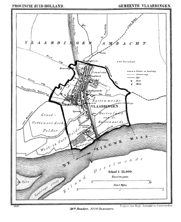
gemeente atlas van nederland - south holland
old maps of vlaardingen
gemeente atlas van nederland - south holland
1860s maps of south holland
gemeente atlas van nederland - south holland
19th-century maps of rotterdam
gemeente atlas van nederland - south holland
1860s maps of south holland
gemeente atlas van nederland - south holland
19th-century maps of rotterdam
gemeente atlas van nederland - north holland
old maps of alkmaar
gemeente atlas van nederland - south holland
19th-century maps of rotterdam
gemeente atlas van nederland - north holland
old maps of haarlem
gemeente atlas van nederland - south holland
1860s maps of south holland
gemeente atlas van nederland - south holland
1860s maps of south holland
gemeente atlas van nederland - gelderland
varsseveld
gemeente atlas van nederland - south holland
maps of stompwijk
gemeente atlas van nederland - south holland
1860s maps of south holland
gemeente atlas van nederland - south holland
maps of piershil
gemeente atlas van nederland - south holland
maps of goudswaard
gemeente atlas van nederland - north holland
19th-century maps of amsterdam
gemeente atlas van nederland - south holland
maps of lisse
gemeente atlas van nederland - south holland
1860s maps of south holland
maps in the library of congress
maps of alexandria, virginia
gemeente atlas van nederland - south holland
maps of zuid-beijerland
gemeente atlas van nederland - south holland
strevelshoek
gemeente atlas van nederland - south holland
1860s maps of south holland
gemeente atlas van nederland - south holland
maps of heerjansdam
gemeente atlas van nederland - south holland
1860s maps of south holland
gemeente atlas van nederland - north holland
maps of zandvoort
gemeente atlas van nederland - south holland
1860s maps of south holland
gemeente atlas van nederland - north holland
old maps of haarlem
gemeente atlas van nederland - north holland
maps of bloemendaal
gemeente atlas van nederland - north holland
maps of muiden
gemeente atlas van nederland - south holland
1860s maps of south holland
gemeente atlas van nederland - south holland
1860s maps of south holland
gemeente atlas van nederland - south holland
maps of hendrik-ido-ambacht
gemeente atlas van nederland - south holland
old maps of delft
gemeente atlas van nederland - north holland
old maps of haarlem
gemeente atlas van nederland - south holland
1860s maps of south holland
gemeente atlas van nederland - south holland
maps of ameide
gemeente atlas van nederland - south holland
1860s maps of south holland
gemeente atlas van nederland - south holland
maps of haastrecht
gemeente atlas van nederland - south holland
old maps of eiland van dordrecht
gemeente atlas van nederland - south holland
19th-century maps of rotterdam
gemeente atlas van nederland - south holland
1860s maps of south holland
gemeente atlas van nederland - north holland
maps of bergen, north holland
gemeente atlas van nederland - south holland
1860s maps of south holland
gemeente atlas van nederland - south holland
1860s maps of south holland
gemeente atlas van nederland - south holland
1860s maps of south holland
gemeente atlas van nederland - south holland
1860s maps of south holland
gemeente atlas van nederland - south holland
maps of krimpen aan de lek
gemeente atlas van nederland - north holland
19th-century maps of amsterdam
maps of nieuwpoort, south-holland
vestingwerken nieuwpoort
gemeente atlas van nederland - south holland
1860s maps of south holland
gemeente atlas van nederland - south holland
maps of koudekerk aan den rijn
gemeente atlas van nederland - north brabant
herpen
gemeente atlas van nederland - north brabant
huisseling
the loyal west in the times of the rebellion
1803 maps of the united states
gemeente atlas van nederland - south holland
19th-century maps of rotterdam
19th-century maps of russia
russia in the 1860s
maps of polders in zeeland
maps of terneuzen
gemeente atlas van nederland - north brabant
maps of willemstad, north brabant
gemeente atlas van nederland - south holland
1860s maps of south holland
gemeente atlas van nederland - south holland
giessen (river south-holland)
gemeente atlas van nederland - south holland
maps of waddinxveen
gemeente atlas van nederland - south holland
giessen (river south-holland)
maps of nieuw-helvoet
nieuw-helvoet
gemeente atlas van nederland - north holland
old maps of amsterdam
gemeente atlas van nederland - south holland
old maps of the hague
gemeente atlas van nederland - south holland
old maps of brielle
gemeente atlas van nederland - south holland
1860s maps of south holland
gemeente atlas van nederland - north holland
bennebroek
gemeente atlas van nederland - south holland
19th-century maps of rotterdam
the loyal west in the times of the rebellion
1865 maps of the united states
gemeente atlas van nederland - south holland
1860s maps of south holland
gemeente atlas van nederland - south holland
1860s maps of south holland
gemeente atlas van nederland - south holland
1860s maps of south holland
gemeente atlas van nederland - south holland
maps of zoeterwoude
gemeente atlas van nederland - south holland
1860s maps of south holland
gemeente atlas van nederland - south holland
1860s maps of south holland
gemeente atlas van nederland - south holland
1860s maps of south holland
gemeente atlas van nederland - north holland
maps of beemster
gemeente atlas van nederland - south holland
maps of geervliet
101 - 200 of 548
Next page
/ 6